New volunteer team to study Baltimore’s storm resiliency
 This article originally appeared on Patch.com
If there was one thing Erik Meyers, vice president of The Conservation Fund, learned from Hurricane Sandy, it was that the current methods for enhancing critical infrastructure in Maryland needed a new look. Previous methods and structures that were designed to protect the state from storm surge and flooding are not living up to their billing and new methods need to be explored and implemented to lessen potential damage in the future.
“So we are looking at new approaches, especially how we could utilize natural features, both in terms of just conserving those features, but also strategies to enhance them, in a way that would offer protection to adjacent communities, that would insulate against catastrophic damage and loss,” Meyers said. “That was a key realization from Sandy.”
To better protect the economic center of Maryland, Meyers and his colleagues assembled a voluntary team of leaders from governmental, private and nonprofit agencies to form the Greater Baltimore Wilderness Coalition. The group developed strategies to conserve, enhance and protect green infrastructure creating plans for more efficient buffers that eliminate or reduce the impacts of intense storms and rising sea level.
The project was funded by a $583,564 grant that the National Fish and Wildlife Foundation awarded to The Conservation Fund, a nonprofit headquartered in Virginia that specializes in environmental work. The award was part of the Hurricane Sandy Coastal Resiliency Competitive grants program.
A major focus of the project was the development of a climate resiliency interactive map created by a collaboration of experts from organizations such as the American Planning Association, U.S. Geological Survey, and U.S. Fish and Wildlife Service. By assessing three primary rivers and several small watersheds that flow into the Chesapeake Bay, project partners identified key strategies to take advantage of the topography and other characteristics of f forests, wetlands, parks, waterways, ranches, and farms, to improve resiliency against future severe storms.
Subscribe to the Baltimore newsletter
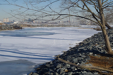
The downpours cause sea level rise, resulting in an overflow of water in the inland stream network of the City of Baltimore that empties into the coastline areas.
The plan is to use enhanced natural resources that can act as a buffer against flooding and storm surges, which would in turn protect habitat and surrounding communities.
Project coordinators named five strategies: protect natural resources, enhance and restore tree canopy, implement multi-benefit green storm water infrastructure, protect critical infrastructure, and defend the coast.
“The objective is to find opportunities for improvements based on these strategies and prioritize them to help local and state governments identify the best approaches to use natural resources to increase resiliency,” Meyers said.
The project coordinators have completed the grant-funded work, which focused on the production of interactive maps and specific planning guides designed for local governments. The remaining work centers on the implementation of the strategies which varies amongst localities.
“Most of the decisions around land uses are made at a local government level, and they don’t have a lot of reasons to coordinate with each other,” Meyers said. “So we wanted to look at how, on a regional basis, protection of green infrastructure to increase resiliency could be advanced, as well as where and how that could happen.”
Next step is to carry out the methods identified by the resiliency map to create a green infrastructure resiliency network on the ground.
The coalition includes local, state and federal agencies such as Baltimore City, Maryland Department of Natural Resources, U.S. Fish and Wildlife Service, U.S. Forest Service, and Hartford County Department of Planning and Zoning. Group members meet regularly and discuss ways to turn ideas and plans created by the resiliency map into actions on the ground.
“We are sending the message that there is more than enough for all of these agencies, all of these nongovernmental organizations, and all of the coalitions to do,” Meyers said. “We are best doing it by actively collaborating with one another, and trying to push tangible projects forward, so people get excited about the possibility of improvement, and could see it, and feel it, experience it on the ground.”
The resiliency map could be found on http://resiliency.cicapps.org/coastal-resiliency/resiliency-maps/. For more information about the Greater Baltimore Wilderness Coalition, please visit: http://www.baltimorewilderness.org/whoweare/.